Ride To Back Bay, Newport, CA
This is part 2 of 3 Scenic Rides in Southern California this is the
Ride To Back Bay
Part 1 – Ride To Dana Point & San Clemente is here.
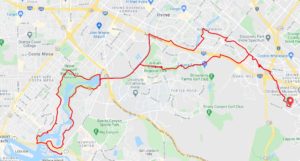
The ride starts from Los Olivos Community Park in Irvine.
More photos of this ride are here.
This version of the route is about 33 miles
For a shorter ride, you could drive to Back Bay and ride the 10.5 mile loop trail.
This ride is about 90% on multi use trails, with plenty of rest stops.
Los Olivos Park has free parking and rest rooms.
What I really like about this ride is the lack of traffic and the scenery.
There are some hills, mostly on the back end, but nothing too long or too steep.

To start, turn right out of the parking lot and pick up the trail at the end of the road. Also a right turn.
Do note that you will cross the road to the other side at two locations.

Riding along the canal is nice, though there is rarely any water in it.
When you cross the foot bridge around mile 6, there is a park with open rest rooms and a place to park your bicycle.
The ride continues past a small lake, on the bike path. You will then ride on the road for three or four blocks, before picking up the bike path along Interstate 405.
There is on tricky crossing at the end, but there is a stop light.
Eventually you will actually return to the original bicycle path (this way was a little shorter), for a straight run to Back Bay, at about mile 11.
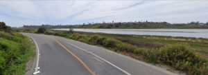
As you ride down into Back Bay (bicycles two way, cars one way only), you are hit with this view.

Take your time and enjoy several miles of super scenic cycling.
At the Marina, you want to go in via the pedestrian gate and cross over the bridge. If you miss this, you can pick up the bike trail just before Pacific Coast Highway.
At PCH, cross over and ride just over a mile to Java Coffee. If you do not want the extra miles, you can just cross the street to Starbucks. The route comes back to PCH.
After you climb the hill, you will be on the cliffs above the bay.

After awhile you will wind up on quiet roads in a really upscale neighborhood.
Eventually, you will wind up on the other side of the Back Bay Loop.
On the way back, the route map has you exiting the bike trail at Harvard and riding along the road, for awhile.
Should you stay on the bike trail, that will also take you back to the start with a couple of extra miles.
Glenn Abelson